Accessibility options by NETOYED
Language

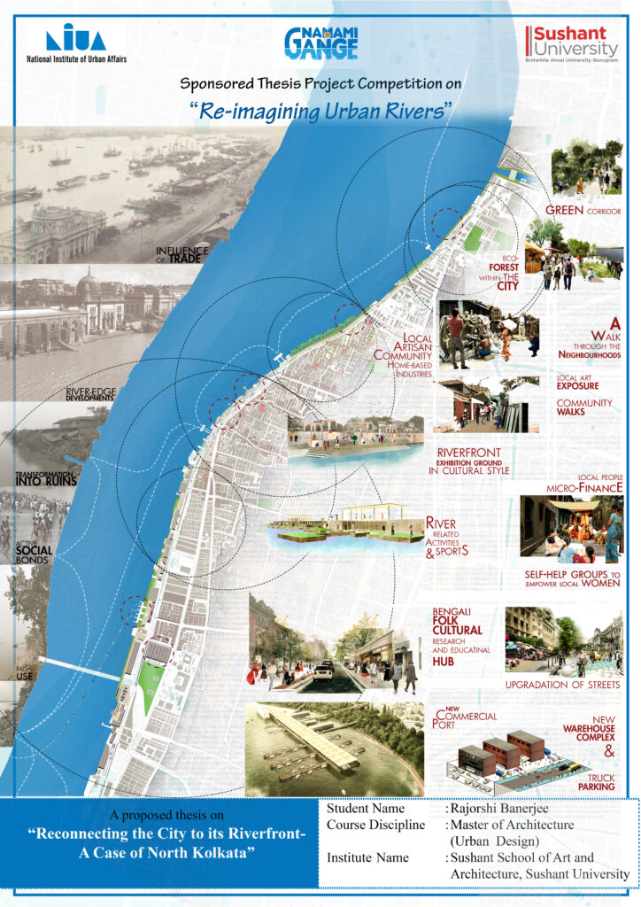
Kolkata, owes its rich heritage to its strategic location along the Hooghly River, a distributary of the Ganges. Once a vibrant lifeline, the riverfront has languished, marked by dilapidated structures and a disconnect from the city. Recent neglect has turned it into the city’s neglected backyard, resulting in environmental and urban challenges. This research delves into this social disconnect, seeking to revive the lost values of Kolkata’s urban river through cultural and social reawakening. It proposes a framework, a tapestry woven with threads of tradition and contemporary art, to strengthen the city’s bond with its river. By empowering local communities and fostering vibrant public spaces, this vision aims to reclaim Kolkata’s lost jewel, rekindling the magic of the Hooghly and rediscovering the intertwined destiny of the city and its river.
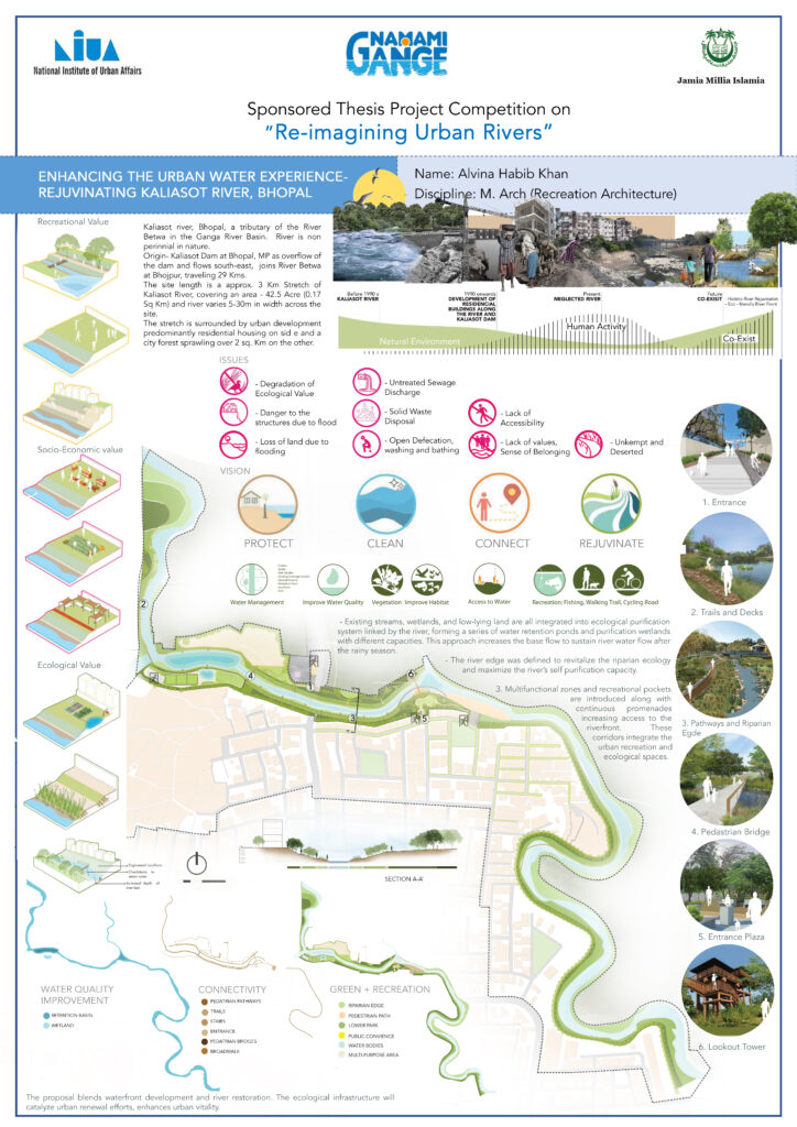
Urban rivers are crucial for city life, yet often face neglect and degradation. This paper explores the challenges of non-perennial rivers like Bhopal’s Kaliasot, a tributary of the Betwa River. It emphasizes the need for a holistic approach to river conservation, focusing on reviving water flow and developing engaging waterfronts. Drawing on existing literature and the Kaliasot case study, the paper proposes strategies for transforming neglected urban rivers into vibrant hubs for social, cultural, and recreational activities. By improving water quality and developing attractive riverfronts, we can reconnect people with these forgotten waterways and restore their ecological and societal value.
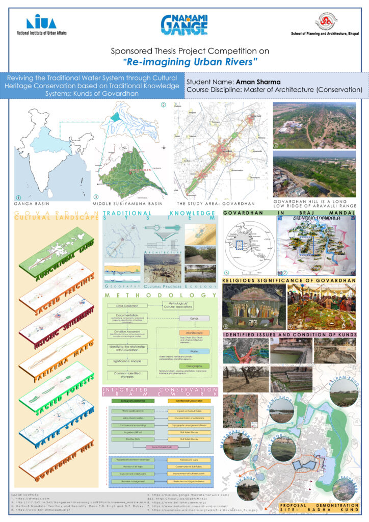
Nestled in Braj Bhoomi, Govardhan’s 49 kunds weave a story of cultural wisdom and environmental harmony. These sacred ponds, dotting the 21km parikrama path, served as lifelines for communities – quenching thirst, nurturing cattle, and fostering rituals. This research delves into the traditional knowledge behind their design and construction, revealing their role as part of a larger water system in this semi-arid region. Preserving these kunds requires recognizing them as an interconnected symphony of nature and culture, paving the way for future conservation efforts.
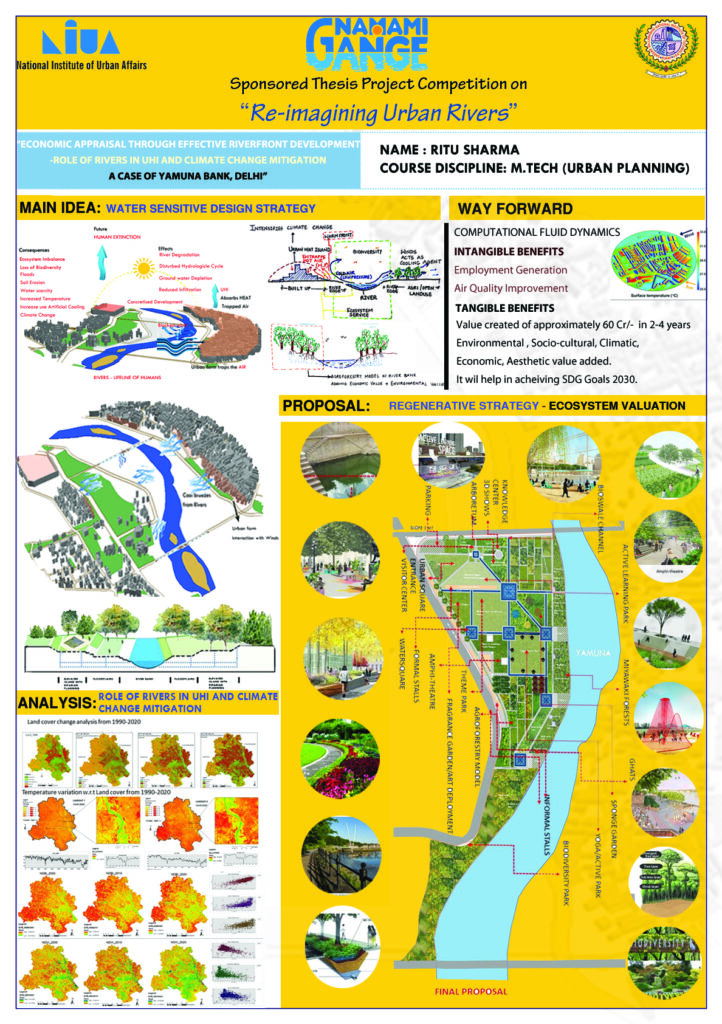
This study emphasizes the vital role of rivers in urban environments and addresses challenges faced by urban rivers, particularly in the Ganga basin. Focusing on mitigating Urban Heat Islands (UHI), it proposes a prototype for an effective riverfront that enhances social connections, evaluates ecosystem benefits, and projects a potential value for initial two years. The research aims to guide proactive city planning and government measures to combat climate change’s adverse effects.
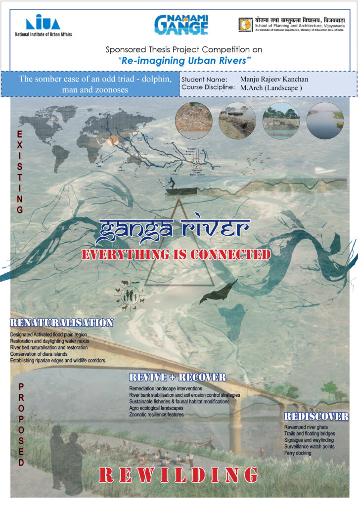
This research focuses on zoonotic resilience in urban riverine landscapes, exemplified by the Vikramshila Gangetic Dolphin Sanctuary in Bihar. Linking landscape architecture to disease prevention, it proposes a scalable design framework. Emphasizing proactive planning and interdisciplinary collaboration, the approach mimics natural environments to mitigate zoonotic spillover, showcasing the discipline’s potential in curbing infections at early stages for urban health.
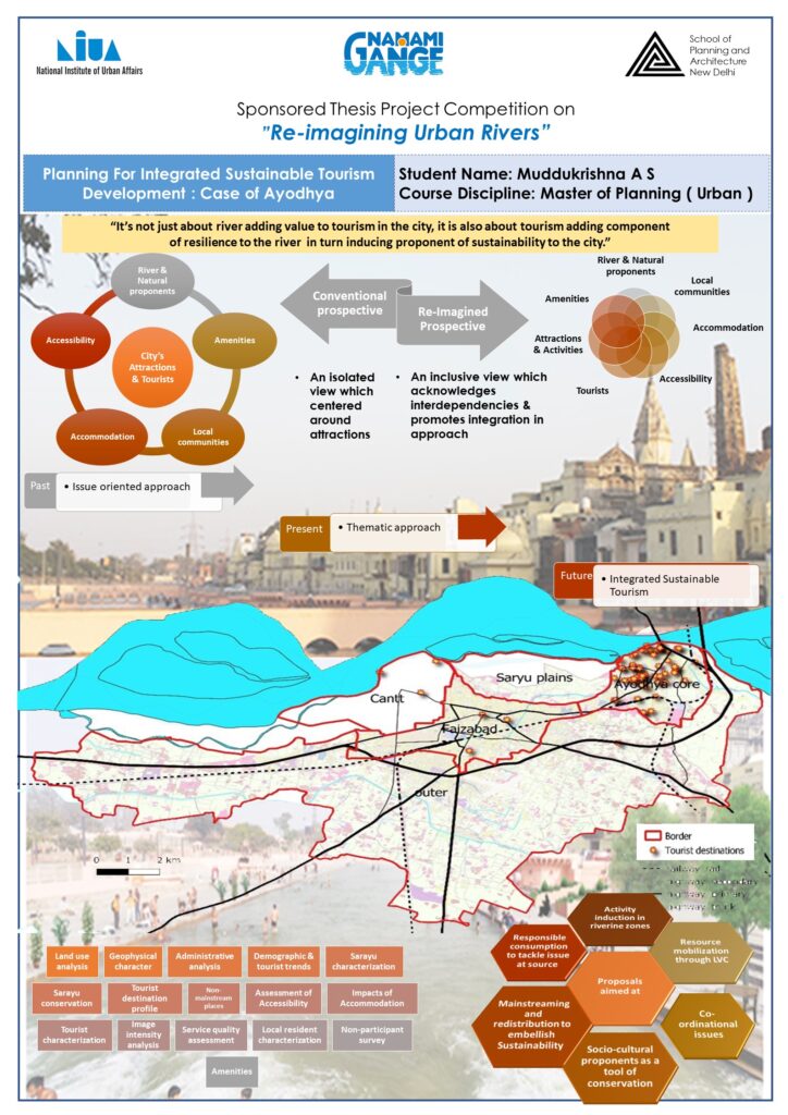
Tourism, once just for leisure, now holds the power to drive comprehensive development across various UN SDGs. This shift demands new approaches like “Destination Development through Tourism.” While existing methods often focus on infrastructure or themed attractions, they lack a holistic view. This paper proposes an integrated, sustainable approach for Ayodhya, considering not just the “5A’s” of tourism (Accessibility, Accommodation, etc.) and the travel trade, but also crucial social and environmental factors. This comprehensive framework aims to ensure Ayodhya’s growth benefits both visitors and residents while protecting its unique heritage and environment.
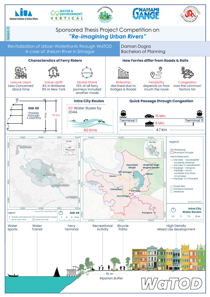
The Water Transit-oriented development (WaTOD) model aims at preparing a development plan by directing importance to water bodies as an element of transit-based growth. The development model under current study recommends on creating a relationship between livelihood and water bodies to create a sense of attachment by converting water into an asset than a barrier.
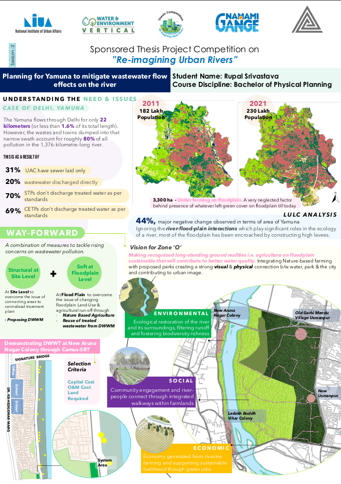
One of the most polluted tributaries of the river Ganga is the river, Yamuna. The report attempts to demonstrate the interwoven nature of river water quality and ever-increasing issues related to wastewater, revealing the way each aspect is related to one another. It also attempts to show the potential of Decentralised Wastewater Management along potential of nature-based solutions can be a feasible approach for improving water quality as well as better community liveability with greater social benefits.
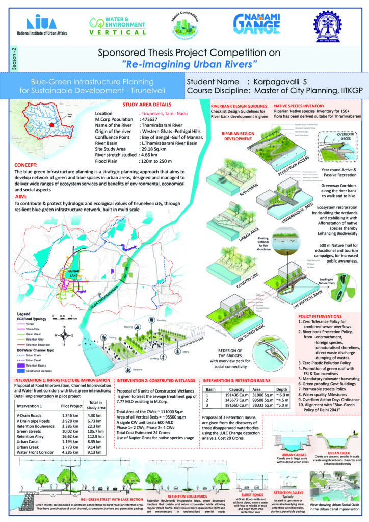
Thamirabarani River Origins from western ghats and travels through Tirunelveli and Tuticorin District for 87 kms length. In the study area, 4.66 km of River stretch is present. Through techno-economical assessment has been carried out in this study to implement Road Improvisation with Blue-Green Elements, Water Channel Improvisation, Riparian Region Regulations & Policies, Riparian Region Regulations & Policies, Constructed Wetlands (VS-SF), Retention Basins.
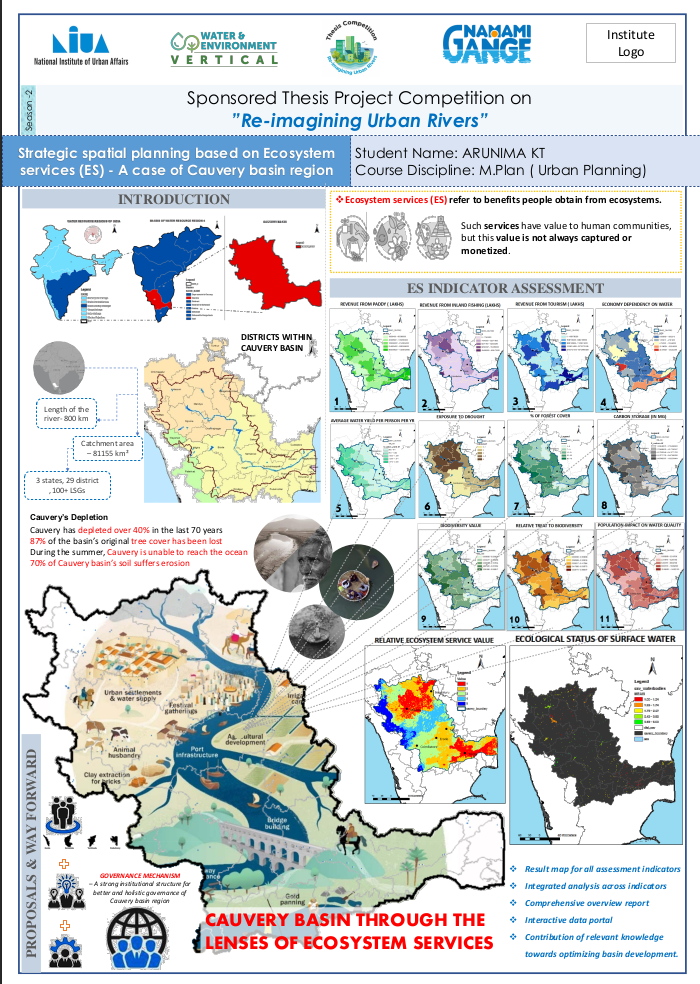
Administrative boundaries separate the ecosystem or eco-regions, which are intended to be a single entity for government convenience, they can never be considered independently. This thesis aims to develop a workable spatial planning strategy for a watershed region using ecosystem services as a central focus. The study additionally uses the InVEST model and the advanced spatial analysis function of the geographic information system (GIS) for ES spatial mapping.
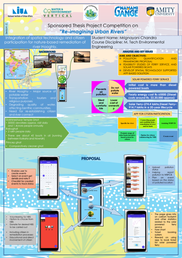
In need of a sustainable approach to find an environment friendly solution to clean rivers, this study encourages nature-based solution to improve the water quality of our rivers and usage of solar powered boats and biofuels. to promote the citizen involvement in mitigating pollution-based challenges in river, an app UI is built using Flutter Flow to promote cleaning of rivers through an app-based approach. The app is further editable and extendable and shows how an app can be used to make data accessible to citizen and encourage then to clean the river and its bank and contribute to nature.
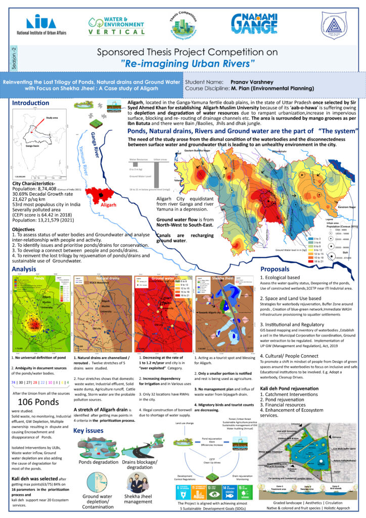
Aligarh City situated nearly equidistant from river Ganga and river Yamuna in a low-lying depression. The aim of the study was to Formulation of strategies for reinventing the lost trilogy of Ponds, Natural drains and Ground Water for Aligarh city and Shekha Jheel. Ecological, landuse based, citizen engagement and institutional and regulatory mechanism-based approaches are recommended to achieve the aim of study.
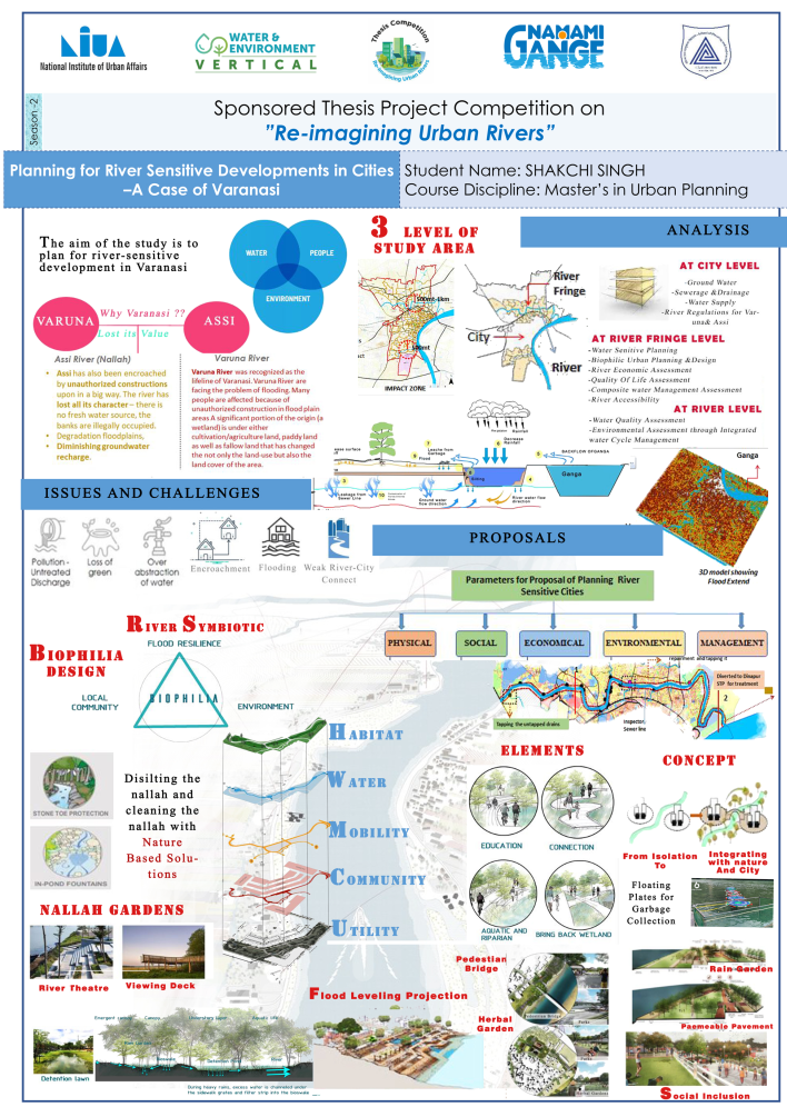
Aim of the study was to create an ecologically sensitive, resilient, recreational space along the Varuna and Assi through urban river regulations for a better biophilic and water sensitive development and growth in the city. Urban River Management Plan Index has been thoroughly used to identify the status quo of eco-friendly riverfront, and social aspects of rivers. Various scenarios have been generated to project the improvements in Assi and Varna River of Varanasi.
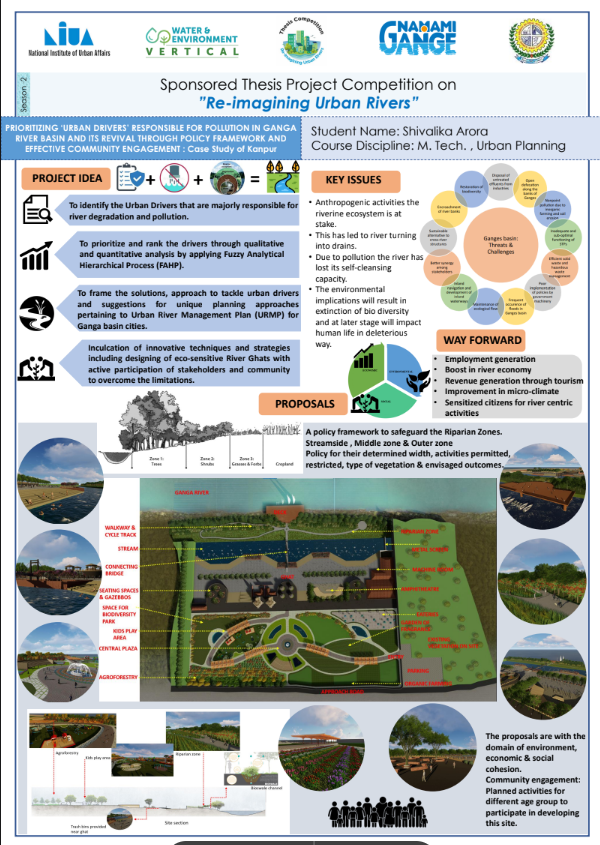
Fuzzy Analytical Hierarchical Process which is a Multi criteria Decision Making Model has been adopted to give the ranking to factors. A ranking framework is developed based on results as to which issues must be addressed first depending upon their level of criticalness. This would also be effective in the budget allocation process. Ultimately a policy framework for the ‘Riparian Zone’ has been proposed. In terms of river rejuvenation, the most vital entity is achieving back the selfcleansing property of river that has been deteriorating. There exists CRZ (Coastal Regulation Zones) but an appropriate policy framework to safeguard the river, restore its lost ecology its in order to seize up the encroachment and construction activities in the riparian zones
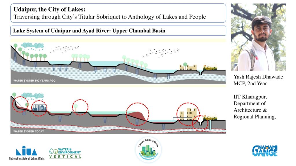
Udaipur has faced water shortage despite its historical association with an interlinked system of lakes. The city’s water demand has surged to 140 million litres per day (MLD), while the available supply remains constant at 103 MLD, with significant losses due to pipeline leakages. Historical precipitation data suggest that Udaipur’s rainfall could meet its water needs if managed with an alternate system. Thus, this study explores the potential for decentralising urban water infrastructure (UWI) by utilising rainwater harvesting to bridge the demand-supply gap, focusing on sustainability, resilience, and effective governance tools for implementation.
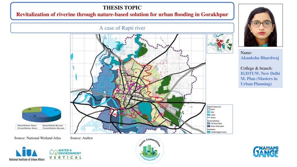
This research aims to utilise urban wetland ecosystems to reduce urban flooding risk, focusing on the Rapti riverine wetlands in Gorakhpur to mitigate flooding using nature-based solutions. Using a case-based approach to wetland planning, the study employs a mixed-methods approach to access the Rapti riverine wetlands. It combines qualitative methods like expert surveys, case studies, and report analysis with quantitative approaches such as primary surveys and Geographic Information System (GIS) analysis to develop policy and infrastructure-based solutions.
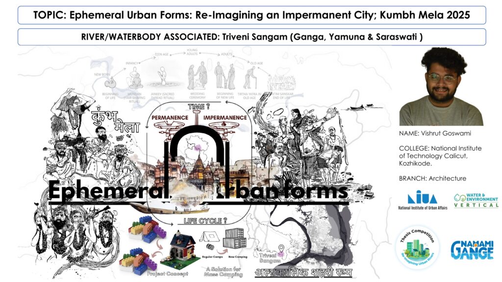
This research explores the transformative potential of ephemeral forms – temporary installations at urban river edges, highlighting their role in revitalising these areas. By activating river edges, these structures create vibrant public spaces that draw people to the water and promote recreational use and environmental stewardship while offering flexible solutions for urban planners and developers. Through a series of case studies, this paper demonstrates how temporary urbanism, driven by ephemeral forms, can reimagine urban river edges, fostering sustainable, inclusive, and economically viable waterfronts that reconnect communities with their rivers.
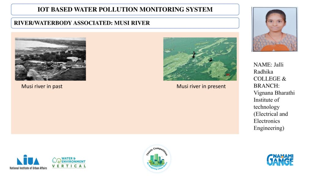
This paper aimed at a solution in the form of an IoT-based trash-collecting boat designed to autonomously and efficiently remove debris from water surfaces. The proposed system integrates components, including sensors and communication modules, into a robust and agile boat platform. This IoT-based trash-collecting boat represents a significant step forward in the fight against water pollution, offering an efficient and sustainable solution to help keep our oceans and waterways clean.
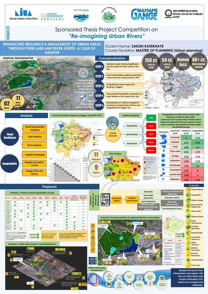
This paper envisions a holistic approach by recognising the interconnectedness of water bodies in Nagpur and addressing them as a unified system. The research follows three steps: Flood Vulnerability Mapping, application of Kevin Lynch’s theory and the development of multifunctional strategies with co-benefits addressing flood resilience and imageability simultaneously. The findings delineate strategies and recommendations for crafting a flood-resilient and visually captivating cityscape, where water bodies are acclaimed as lifelines and landmarks, enhancing the city’s appeal and safeguarding its future.
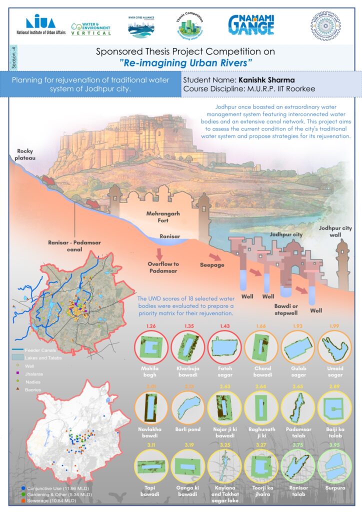
The founders of Jodhpur emphasised the water potential for the city, but over time, the development of the city has led to the deterioration of its traditional water system. This study focuses on understanding this water system and brings to light its historic, cultural and environmental significance by evaluating the water quality of traditional water bodies using a water quality test for selected water bodies at the PHED lab of Jodhpur. The Urban Water Diagnostic Tool was used to understand and highlight the level of deterioration the traditional water bodies were facing through a priority matrix.
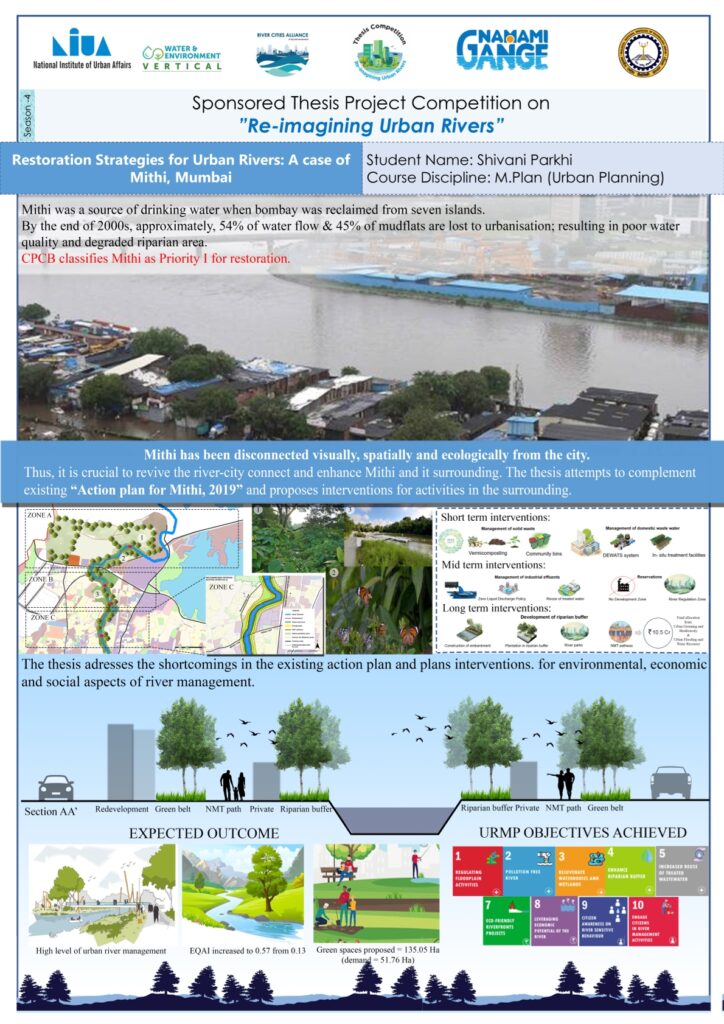
Increasing urbanisation and development activities along the Mithi have drastically altered the natural river channel, causing frequent occurrences of floods, the emergence of severe encroachments, water pollution by industrial effluents discharged into the river, etc. This paper revolves around issues of the floodplains of Mithi and identifies the possibilities of restoration by a comprehensive understanding of existing frameworks in India. Additionally, an attempt to formulate restoration strategies for Mithi with an integration of urban blue-green infrastructure in the riparian areas has been made.
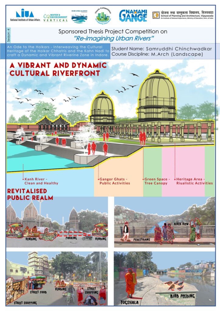
This study focuses on reviving the cultural and ecological essence of Indore’s Khan Nadi and Holkar Chhatris by adopting a community-centric riverfront approach. Moving beyond mechanical beautification, it envisions creating inclusive public spaces that reconnect citizens with their heritage, foster cultural expression, and restore the river’s ecological and social value, giving Indore a vibrant and identity-rich urban landscape that unites culture, community, and ecology.
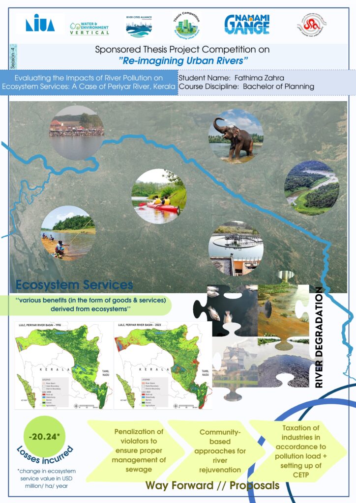
Intensification of land use has led to a shift in the functions of the riverine ecosystem. This study evaluates the impacts of pollution on the major ecosystem services provided by the Periyar River, which has been subject to extreme industrial pollution. It also analyses the temporal changes to understand the extent of pollution’s impact. A rapid participatory appraisal method was undertaken to study local perceptions of river value and degradation.
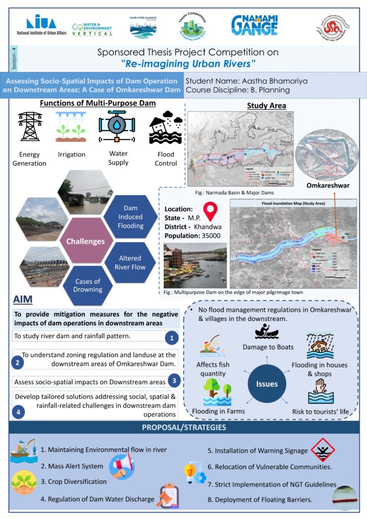
The Omkareshwar Dam, built on the Narmada River in 2007, holds cultural and religious significance in the Khandwa district. This research investigates the socio-spatial nature of this dam on downstream areas and aims to develop strategies to mitigate adverse effects on communities and the environment. The methodology combines a comprehensive literature review with quantitative and qualitative analysis. By offering actionable measures and policy interventions, this research seeks to enhance understanding of the socio-spatial dynamics influenced by dam operations and promote sustainable development practices in river basin management.
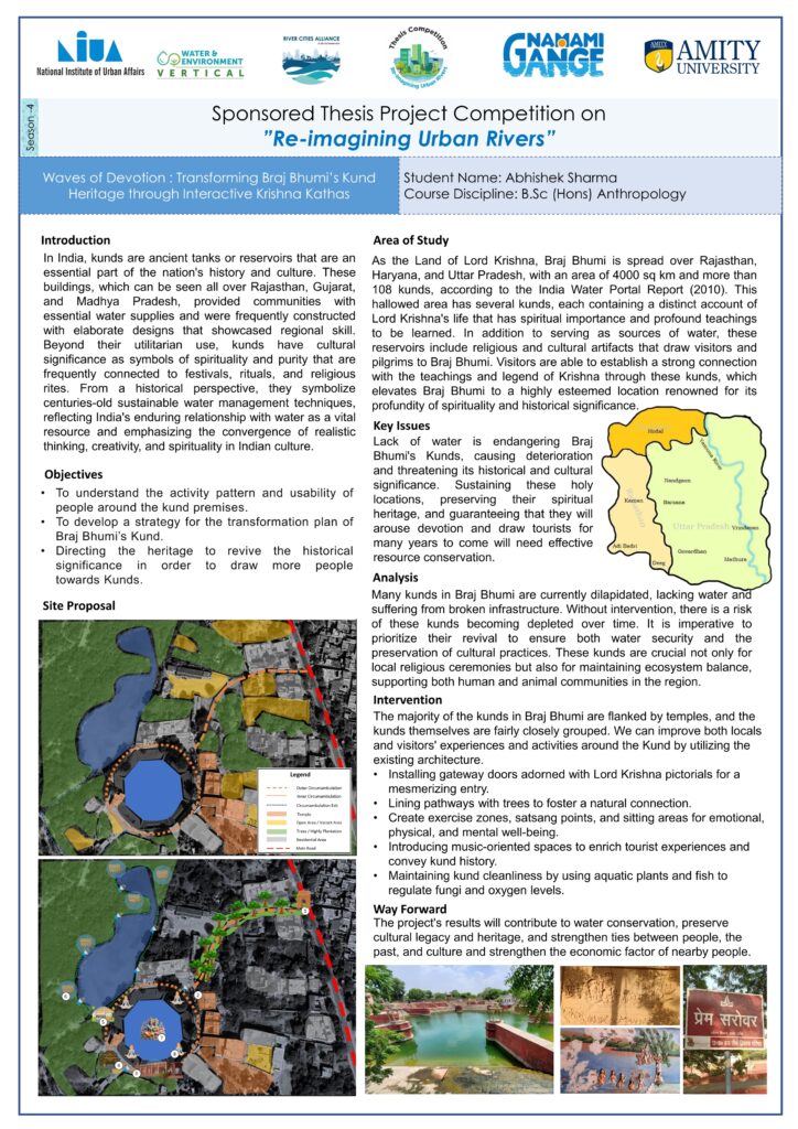
This paper aims to connect people with the cultural heritage of Braj Bhumi by probing the revival of the region’s kund heritage through the incorporation of Krishna legends. Qualitative techniques, including focus groups, pre-tested interview schedules, and visual documentation from temple priests, local people, and tourists with observations, have been used to maintain a strong focus on ecological sustainability and community involvement, emphasising the function that animals, plants, and water management play in preserving the kund ecosystems. The initiative uses cutting-edge technology, such as Virtual Reality (VR) experiences, to inform and interest guests about the rich history and legends connected to each kund.
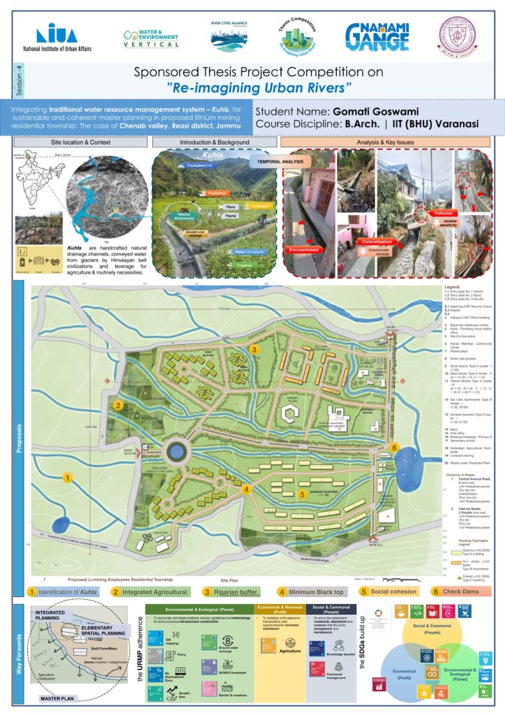
This paper explores Kuhls, a cryosphere-fed communal water conveyance channel system local to the Himalayan areas, which also supports the riparian ecosystems along its course. Kuhls have witnessed serious threats in recent years with observed changes in their form, understanding, traditional coherence and ecological relevance. The study uses Participatory Rural Appraisal (PRA) tools, case study documentation, and open-ended interviews with primary stakeholders, aiming to raise awareness and encourage responsible action from both citizens and relevant authorities in safeguarding these vital water systems.
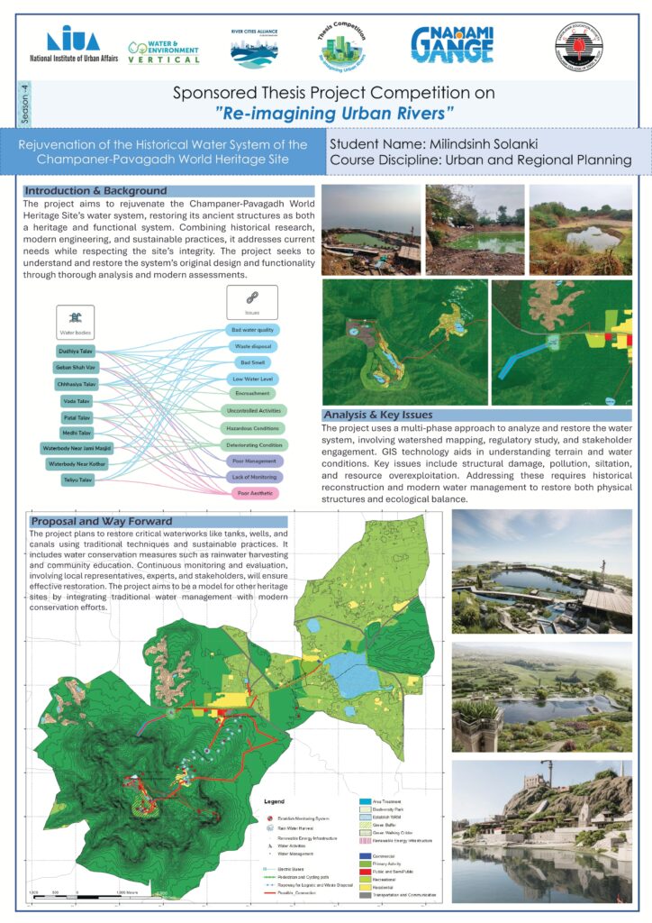
Known for its sophisticated medieval water systems, Champaner-Pavagadh is a UNESCO World Heritage site. The Pavagadh hills feature tanks for rainwater collection, while Champaner showcases a network of wells and stepwells. Recent neglect, pollution, and modern development have led to the decline of these systems, threatening the region’s cultural heritage. This thesis aims to identify the causes of this degradation and propose solutions to restore Champaner-Pavagadh’s water management systems. By integrating historical research with modern engineering and sustainable practices, the solutions aim at preserving these ancient marvels for future generations and reintroducing traditional water management techniques for contemporary use.